Google Research and NASA JPL Unveil Deep Learning Model to Revolutionize Global Methane Emission Detection

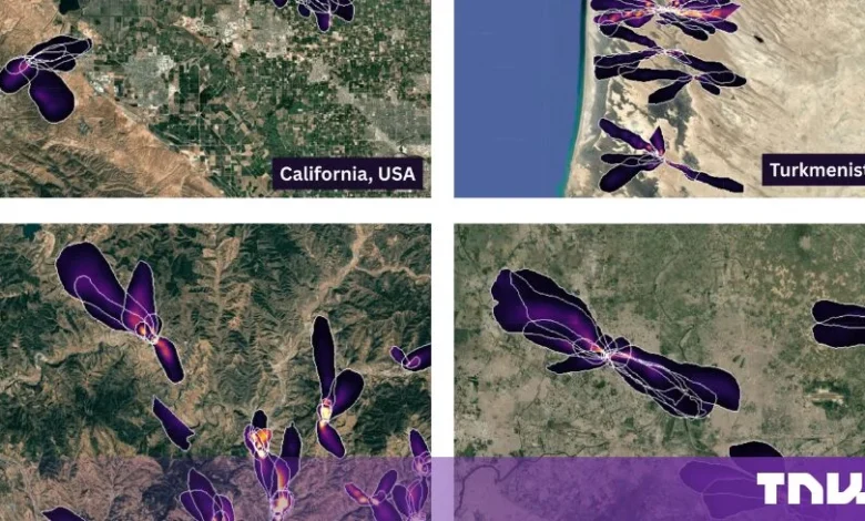
The global effort to mitigate climate change has reached a significant technological milestone with the release of a sophisticated deep learning model capable of mapping methane plumes from space with unprecedented precision. Developed through a collaboration between Google Research and NASA’s Jet Propulsion Laboratory (JPL), this new tool utilizes a vision transformer architecture to identify methane leaks at a resolution of 60 meters per pixel. By analyzing raw spectral data from NASA’s Earth Surface Mineral Dust Source Investigation (EMIT) instrument—which currently orbits aboard the International Space Station (ISS)—the model has successfully identified 23,000 additional methane plumes that previously eluded human analysts and older automated systems. This development marks a critical shift in atmospheric monitoring, moving from broad regional estimates to site-specific accountability.
The Technological Leap: Vision Transformers in Orbit
The core of this innovation lies in the transition from traditional, manually intensive image processing to deep learning-based automation. The model is trained on a massive dataset of 3.6 million simulated methane plumes, allowing it to recognize the unique spectral signatures of the gas against complex terrestrial backgrounds. Unlike earlier iterations of satellite analysis, which often suffered from high false-positive rates or failed to distinguish between closely clustered emission sources, this vision transformer architecture excels at spatial pattern recognition.
By processing data at a 60-meter resolution, the model can pinpoint individual landfill cells, specific industrial pipelines, and storage facilities. This is a dramatic improvement over existing global monitoring solutions, such as the Copernicus Sentinel-5P satellite, which provides daily global coverage but operates at a spatial resolution of roughly 5.5 by 3.5 kilometers. While Sentinel-5P remains an indispensable tool for tracking large-scale atmospheric trends, it functions more as a wide-angle lens, identifying regions of concern rather than specific infrastructure failures. The Google-NASA model, by contrast, acts as a high-powered microscope, providing the granular detail necessary for actionable regulatory intervention.
Chronology of Methane Monitoring Evolution
The trajectory of space-based methane tracking has accelerated rapidly over the last several years as global policy has shifted toward more aggressive emission reduction targets.
- 2017: The launch of Sentinel-5P by the European Space Agency (ESA) provided the world with its first truly consistent, high-frequency look at atmospheric methane concentrations.
- February 2023: The European Union’s Copernicus atmosphere service launched a dedicated "methane hotspot explorer," a tool designed to track leaks globally using Sentinel-5P data, spearheaded by Dutch researchers.
- 2023-2024: Analysis from the Carbon Mapper initiative, utilizing EMIT and Planet Labs data, began producing high-resolution lists of the world’s most significant "super-emitter" sites, highlighting the discrepancy between reported emissions and ground-truth realities.
- Mid-2024: Google Research and NASA JPL finalized the integration of their deep learning model, successfully validating it against historical EMIT data and demonstrating its ability to map 24 of the world’s top 25 largest-emitting landfills.
This timeline illustrates a rapid transition from scientific observation to operational intelligence, driven by both the increasing frequency of satellite launches and the maturation of AI processing capabilities.
Bridging the Regulatory Gap: The Waste Sector Challenge
Despite the technological capability to detect these emissions, a significant regulatory disconnect remains. The European Union’s landmark Methane Regulation, which governs how the bloc identifies and mitigates emissions, focuses primarily on the energy sector—specifically oil, gas, and coal. While this is a logical priority given the scale of leaks in these industries, it leaves the waste sector largely unmonitored under official regulatory frameworks.
The implications of this gap are substantial. According to estimates provided in January by Prognos and the ifeu Institute, municipal waste landfilled in Europe between 2022 and 2050 is projected to release approximately 1.5 billion tonnes of carbon dioxide equivalent in the form of methane. Because methane has a global warming potential significantly higher than carbon dioxide over a 20-year period, the failure to regulate landfill emissions represents a massive, unaddressed climate liability.
The new Google-NASA model demonstrates that landfills are among the most persistent and identifiable super-emitters on the planet. By successfully identifying plumes at 24 of the 25 largest-emitting landfill sites, the model provides the exact evidentiary basis required to expand regulatory oversight. The challenge for policymakers, therefore, is no longer a lack of data, but a lack of mandate.
Operational Constraints and the Future of Earth Observation
While the new model represents a triumph of data science, it is not without its limitations. The EMIT instrument was originally designed to map mineral dust in arid regions to help scientists understand how dust affects the global climate. Because it is hosted on the International Space Station, its orbital inclination of 51.6 degrees means it does not cover the high-latitude regions of the Northern Hemisphere, such as much of Europe or Northern Canada. This is a byproduct of the ISS’s unique flight path rather than a design choice, meaning that the world’s "sharpest" methane map is effectively a lucky auxiliary product of a dust-tracking mission.
To address these geographic gaps, the private and public sectors are investing in dedicated monitoring constellations. Companies like AIRMO are raising capital—recently securing EUR 5 million in seed funding—to launch specialized methane-sensing satellites by 2027. Simultaneously, the European Space Agency is preparing the Copernicus CO2M mission, scheduled for launch in November 2027, which will provide a more comprehensive, dedicated view of greenhouse gas emissions.
The Democratization of Climate Data
One of the most profound aspects of this initiative is the commitment to open science. By hosting the plume database on Google Earth Engine under a Creative Commons license and making the model code available on GitHub and Kaggle, the researchers have effectively democratized the ability to conduct high-resolution climate monitoring.
This transparency creates a new paradigm for "citizen science" and regulatory oversight. NGOs, environmental journalists, and local government officials can now access the same data as global climate agencies. If a facility operator claims to be mitigating their methane leaks, a third party can now verify that claim independently using the Google-NASA model. This shift toward "radical transparency" is expected to force a change in corporate behavior, as the cost of hiding or ignoring large-scale emissions becomes prohibitively high.
Analysis of Implications
The emergence of such accessible, high-resolution data creates a "regulatory pull" effect. When tools are freely available, the pressure on lawmakers to act on the data they provide increases. Currently, European Earth observation data is characterized by a surplus of information and a relative dearth of commercial buyers. However, as the legal ramifications of methane emissions—such as potential carbon taxes or non-compliance fines—become clearer, the demand for this specific, site-level intelligence is expected to surge.
Regulators in the European Union and elsewhere face a choice: either update their legislative frameworks to include waste and agricultural methane sources or continue to allow a vast, measurable portion of the climate crisis to remain outside the scope of accountability. The data provided by the Google-NASA collaboration serves as a "call to action" that is difficult to ignore. By shifting the focus from broad regional averages to specific facility-level attribution, the model provides the necessary framework for the next generation of climate policy.
In conclusion, the integration of deep learning with satellite imagery has transformed methane monitoring from an academic exercise into a precision tool for policy enforcement. While challenges regarding orbital coverage and regulatory scope remain, the foundation for a more transparent and accountable approach to greenhouse gas management has been firmly established. As the industry moves toward 2027 and the next generation of dedicated satellite missions, the data now available serves as a vital bridge, ensuring that the world can monitor—and ultimately manage—its most potent climate-warming emissions.